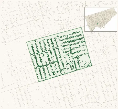
Neighbourhood · #172
Dovercourt Village
2,786 street trees · 0.38 km² · pop. 12,380
What the numbers say
Dovercourt Village is above-average for tree density (22nd of 158), with 2,786 city-owned street trees across 0.38 km² — 7,258 per km².
Tree canopy covers 17.0% of the neighbourhood (122nd of 158) — essentially unchanged since 2008. (This includes all trees — street, park, and private — from the 2018 land-cover raster.)
Across 160 distinct species (Shannon diversity 4.30, 10th of 158), the most common is acer platanoides at 6.3% of the trees.
Most common species here
| Species | Trees | Share |
|---|---|---|
| Norway Maple acer platanoides | 175 | 6.3% |
| White Cedar thuja occidentalis | 156 | 5.6% |
| Silver Maple acer saccharinum | 108 | 3.9% |
| Freeman Autumn Blaze Maple acer x freemanii (a. rubrum x saccharinum) 'autumn blaze' | 96 | 3.4% |
| Honey Locust gleditsia triacanthos | 92 | 3.3% |
The biggest tree on record
A American Elm (ulmus americana) at 216 BARTON AVE — 170 cm DBH, the largest of the 2,786 street trees here. · Street View
Explore
Tree counts and species from the City of Toronto Street Tree dataset (city-owned trees in the road allowance only — not parks or private property). Canopy % and heat proxy derive from the 2018 land-cover raster. Population is from the 2021 census, joined by the 158-neighbourhood model.