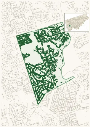
Neighbourhood · #009
Edenbridge-Humber Valley
8,280 street trees · 1.40 km² · pop. 15,190
What the numbers say
Edenbridge-Humber Valley is above-average for tree density (51st of 158), with 8,280 city-owned street trees across 1.40 km² — 5,933 per km².
Tree canopy covers 44.7% of the neighbourhood (8th of 158) — essentially unchanged since 2008. (This includes all trees — street, park, and private — from the 2018 land-cover raster.) Heat-risk proxy ranks it 6th-coolest in the city.
Across 196 distinct species (Shannon diversity 4.23, 34th of 158), the most common is picea pungens at 9.2% of the trees.
Most common species here
| Species | Trees | Share |
|---|---|---|
| Colorado Blue Spruce picea pungens | 763 | 9.2% |
| Norway Maple acer platanoides | 705 | 8.5% |
| Red Oak quercus rubra | 425 | 5.1% |
| Honey Locust gleditsia triacanthos | 318 | 3.8% |
| Sargents Apple malus sargentii | 276 | 3.3% |
The biggest tree on record
A Red Oak (quercus rubra) at 78 VALECREST DR — 190 cm DBH, the largest of the 8,280 street trees here. · Street View
Explore
Tree counts and species from the City of Toronto Street Tree dataset (city-owned trees in the road allowance only — not parks or private property). Canopy % and heat proxy derive from the 2018 land-cover raster. Population is from the 2021 census, joined by the 158-neighbourhood model.