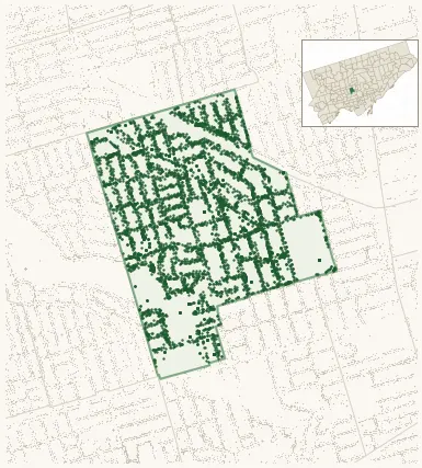
Neighbourhood · #101
Forest Hill South
6,125 street trees · 0.63 km² · pop. 10,860
What the numbers say
Forest Hill South is one of the most tree-dense neighbourhoods in Toronto — 1st of 158, with 6,125 city-owned street trees across 0.63 km² — 9,653 per km².
Tree canopy covers 40.8% of the neighbourhood (17th of 158) — essentially unchanged since 2008. (This includes all trees — street, park, and private — from the 2018 land-cover raster.)
Across 192 distinct species (Shannon diversity 4.06, 89th of 158), the most common is acer platanoides at 15.5% of the trees.
Most common species here
| Species | Trees | Share |
|---|---|---|
| Norway Maple acer platanoides | 948 | 15.5% |
| Colorado Blue Spruce picea pungens | 441 | 7.2% |
| Honey Locust gleditsia triacanthos | 252 | 4.1% |
| Pear Chanticleer pyrus calleryana 'chanticleer' | 216 | 3.5% |
| Austrian Pine pinus nigra | 190 | 3.1% |
The biggest tree on record
A Beech (fagus) at 248 WARREN RD — 199 cm DBH, the largest of the 6,125 street trees here. · Street View
Explore
Tree counts and species from the City of Toronto Street Tree dataset (city-owned trees in the road allowance only — not parks or private property). Canopy % and heat proxy derive from the 2018 land-cover raster. Population is from the 2021 census, joined by the 158-neighbourhood model.