Neighbourhood · #043
Victoria Village
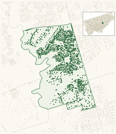
Neighbourhood Improvement Area 4,468 street trees · 1.23 km² · pop. 17,365
What the numbers say
Victoria Village is middle-of-the-pack for street trees (116th of 158), with 4,468 city-owned street trees across 1.23 km² — 3,637 per km².
Tree canopy covers 27.5% of the neighbourhood (69th of 158) — up 11.7 points since 2008. (This includes all trees — street, park, and private — from the 2018 land-cover raster.)
Across 160 distinct species (Shannon diversity 4.11, 74th of 158), the most common is picea pungens at 7.5% of the trees.
Most common species here
| Species | Trees | Share |
|---|---|---|
| Colorado Blue Spruce picea pungens | 334 | 7.5% |
| Norway Maple acer platanoides | 266 | 6.0% |
| Sargents Apple malus sargentii | 256 | 5.7% |
| Austrian Pine pinus nigra | 217 | 4.9% |
| White Birch betula papyrifera | 178 | 4.0% |
The biggest tree on record
A Linden (tilia) at 60 MOBILE DR — 200 cm DBH, the largest of the 4,468 street trees here. · Street View
Explore
Tree counts and species from the City of Toronto Street Tree dataset (city-owned trees in the road allowance only — not parks or private property). Canopy % and heat proxy derive from the 2018 land-cover raster. Population is from the 2021 census, joined by the 158-neighbourhood model.