Neighbourhood · #035
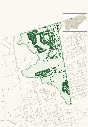
Westminster-Branson
Emerging Neighbourhood 3,190 street trees · 0.94 km² · pop. 25,705
What the numbers say
Westminster-Branson is middle-of-the-pack for street trees (123rd of 158), with 3,190 city-owned street trees across 0.94 km² — 3,407 per km².
Tree canopy covers 32.4% of the neighbourhood (47th of 158) — up 17.8 points since 2008. (This includes all trees — street, park, and private — from the 2018 land-cover raster.)
Across 150 distinct species (Shannon diversity 3.83, 136th of 158), the most common is acer platanoides at 16.3% of the trees.
Most common species here
| Species | Trees | Share |
|---|---|---|
| Norway Maple acer platanoides | 519 | 16.3% |
| Colorado Blue Spruce picea pungens | 242 | 7.6% |
| Honey Locust gleditsia triacanthos | 179 | 5.6% |
| Austrian Pine pinus nigra | 131 | 4.1% |
| White Birch betula papyrifera | 113 | 3.5% |
The biggest tree on record
A Bur Oak (quercus macrocarpa) at 87 FISHERVILLE RD — 135 cm DBH, the largest of the 3,190 street trees here. · Street View
Explore
Tree counts and species from the City of Toronto Street Tree dataset (city-owned trees in the road allowance only — not parks or private property). Canopy % and heat proxy derive from the 2018 land-cover raster. Population is from the 2021 census, joined by the 158-neighbourhood model.