Neighbourhood · #074
North St.James Town
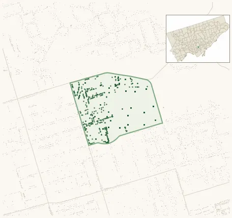
678 street trees · 0.11 km² · pop. 18,535
What the numbers say
North St.James Town is above-average for tree density (40th of 158), with 678 city-owned street trees across 0.11 km² — 6,231 per km².
Tree canopy covers 16.0% of the neighbourhood (127th of 158) — essentially unchanged since 2008. (This includes all trees — street, park, and private — from the 2018 land-cover raster.) Heat-risk proxy ranks it 22nd-hottest in the city.
Across 74 distinct species (Shannon diversity 3.31, 154th of 158), the most common is acer platanoides at 21.2% of the trees.
Most common species here
| Species | Trees | Share |
|---|---|---|
| Norway Maple acer platanoides | 144 | 21.2% |
| Ginkgo ginkgo biloba | 66 | 9.7% |
| Honey Locust gleditsia triacanthos | 61 | 9.0% |
| Siberian Elm ulmus pumila | 34 | 5.0% |
| Green Ash fraxinus pennsylvanica | 23 | 3.4% |
The biggest tree on record
A American Elm (ulmus americana) at 495 SHERBOURNE ST — 110 cm DBH, the largest of the 678 street trees here. · Street View
Explore
Tree counts and species from the City of Toronto Street Tree dataset (city-owned trees in the road allowance only — not parks or private property). Canopy % and heat proxy derive from the 2018 land-cover raster. Population is from the 2021 census, joined by the 158-neighbourhood model.