May 2026 · on the canopy this dataset doesn't see
Stand on the Prince Edward Viaduct, looking north. The Don Valley opens beneath you, forty metres deep, a kilometre across at the widest point, disappearing upstream into a corridor of green that keeps going — past Pottery Road, past Crothers Woods, past Taylor Creek, up into the headwaters somewhere north of Steeles. You are looking at a forest in the middle of Toronto that is bigger than downtown itself.
None of the trees in it appear on treeto.ca. Not one.
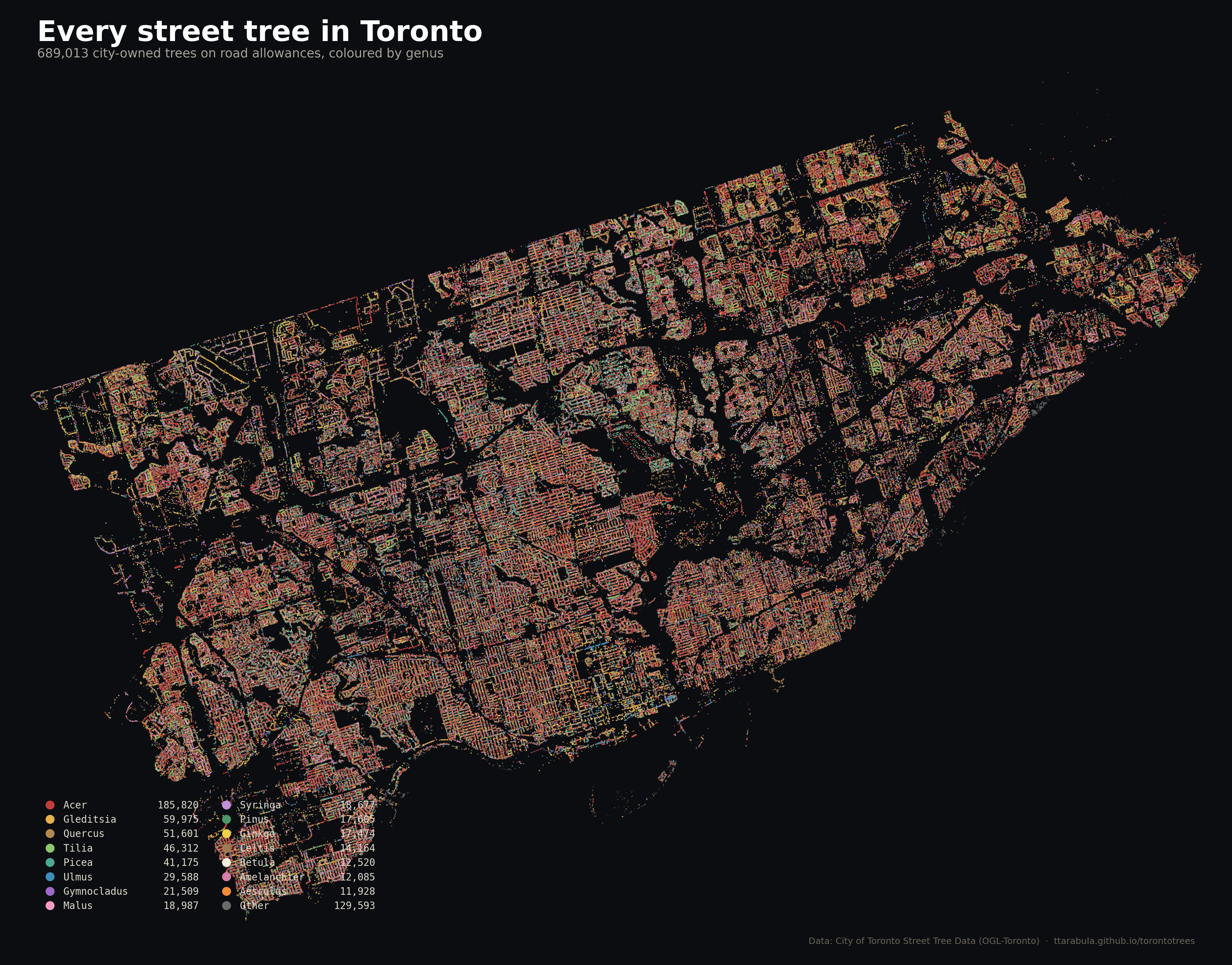
This site runs on the City of Toronto's street-tree inventory — 689,013 rows of trees the forestry department plants and maintains on the road allowance. The ravines are a different jurisdiction, a different management regime, and, by most estimates, a vastly bigger tree population. This post is about what the street-tree dataset doesn't count — and why that matters for every claim the rest of the site makes.
Toronto's ravine system covers roughly 11,000 hectares — 17% of the city's land area. That's one of the largest urban ravine systems anywhere in the world. The Don, the Humber, Highland Creek, Etobicoke Creek, Taylor-Massey Creek, Mimico Creek, the Rouge, and the Lake Ontario bluffs all carve corridors of protected woodland through what is otherwise a fully built-out metropolis.
Toronto's ravines are an accident of disaster policy. In October 1954, Hurricane Hazel ran up the eastern seaboard, stalled over southern Ontario, and dumped 20 centimetres of rain on the Holland Marsh watershed in a single day. The Humber and the Don flooded; eighty-one people drowned, many of them in small flood-plain houses along Raymore Drive in Weston. In the disaster's aftermath, Metro Toronto and the newly-formed Metropolitan Toronto and Region Conservation Authority banned residential construction in the flood plains. Streets that had backed onto the Humber in 1953 now backed onto protected conservation land. Over the following seventy years, those stripes of abandoned low ground grew into forest.
That forest now holds a substantial share of Toronto's actual canopy. The city's 2018 LiDAR land-cover study put Toronto's total tree cover at 28.4% — and in the ravine-heavy neighbourhoods on its polygon boundaries (Bridle Path, Rosedale, Leaside, Riverdale), canopy percentages run 40–60%. That's almost entirely ravine shoulder sliding into the neighbourhood count.
The street-tree inventory is dominated by cultivars — Norway maple, honey locust 'Skyline', Freeman maple 'Autumn Blaze', Kentucky coffeetree, the occasional London plane. It's a list of things that survive on a 2-metre boulevard strip between sidewalk salt and buried utilities. The top species is Norway maple, invasive, and the second is honey locust, a single-genus workhorse the city has been trying to diversify away from for a decade.
A walk into a Toronto ravine shows a different forest. The native Carolinian species that were here before Europeans — eastern hemlock, white pine, American beech, red oak, white oak, sugar maple, shagbark hickory, basswood, slippery elm, hop hornbeam — are the dominant overstory in the older ravine sections. The Don Valley's upper slopes in particular still carry a scattered but intact pre-settlement forest.
The understory adds willows, dogwoods, trilliums, bloodroot, hepatica, Canadian yew. In spring the woodland wildflowers along the Brickworks ravine are denser than anywhere in Toronto's parks. Birds and mammals use the ravine corridors as movement highways: Cooper's hawks, barred owls, red foxes, coyotes, pileated woodpeckers, the occasional deer. None of that exists in the same density on a street.
The invasion pressure flows downhill, too. Norway maple on Toronto's streets has been seeding into the ravines for sixty years, and the ravines have been losing ground to it steadily. Acer platanoides now dominates the edges of Moore Park Ravine, Cedarvale Ravine, and the lower Don. Add garlic mustard, dog-strangling vine, buckthorn, and Japanese knotweed — all originally ornamental plantings that jumped the garden fence — and the ravines' native-species cover is under a slow siege. The city's Ravine Strategy, published in 2020, spends most of its budget on this.
Five of the posts on this blog hedge with "street trees only — not parks or ravines." That caveat isn't pedantic. It changes the story in specific, important ways.
The best way to understand what the ravines are is to walk inside one. Three starter routes, each 2–4 km, each a different flavour of ravine:
These are not street trees. They are not on any map this site builds. But they are the reason Toronto's canopy numbers look the way they do, and they are the half of the city's urban forest that does most of the ecological work — stormwater absorption, slope stability, wildlife corridor, climate refuge, pollen and seed reservoir for the native species the street-tree program is trying to build back into the city.
Next time you see a caveat on this site that reads "street trees only — not parks or ravines," picture the Don Valley on an August afternoon. That is what the caveat is for.
The City of Toronto's Ravine Strategy
Published 2020. Goals, maps, and stewardship programs across 11,000 hectares.
Read it →